
Published documents
Download our latest documents and briefings.
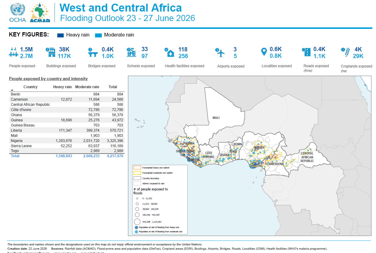
West and Central Africa: 2026 Flooding Outlook (23 - 27 June 2026)
Forecasts for 23–27 June 2026 indicate a continued risk of flooding across parts of West and Central Africa due to widespread moderate and heavy rainfall. Approximately 4.2 million people could be exposed to flooding, including 1.5 million in areas expected to receive heavy rainfall and 2.7 million in areas forecast to experience moderate rainfall. Nigeria is expected to be the most affected country, with more than 3.3 million people potentially exposed, followed by Liberia, Sierra Leone, Côte d’Ivoire, Ghana, Guinea, and Cameroon. Flood exposure could also affect approximately 117,000 buildings, 1,000 bridges, 97 schools, 256 health facilities, 5 airports, 1,100 km of roads, and 29,000 hectares of cropland. The outlook highlights the importance of strengthening early warning systems, preparedness measures, and coordinated response efforts to reduce the potential humanitarian impacts of flooding across the region.
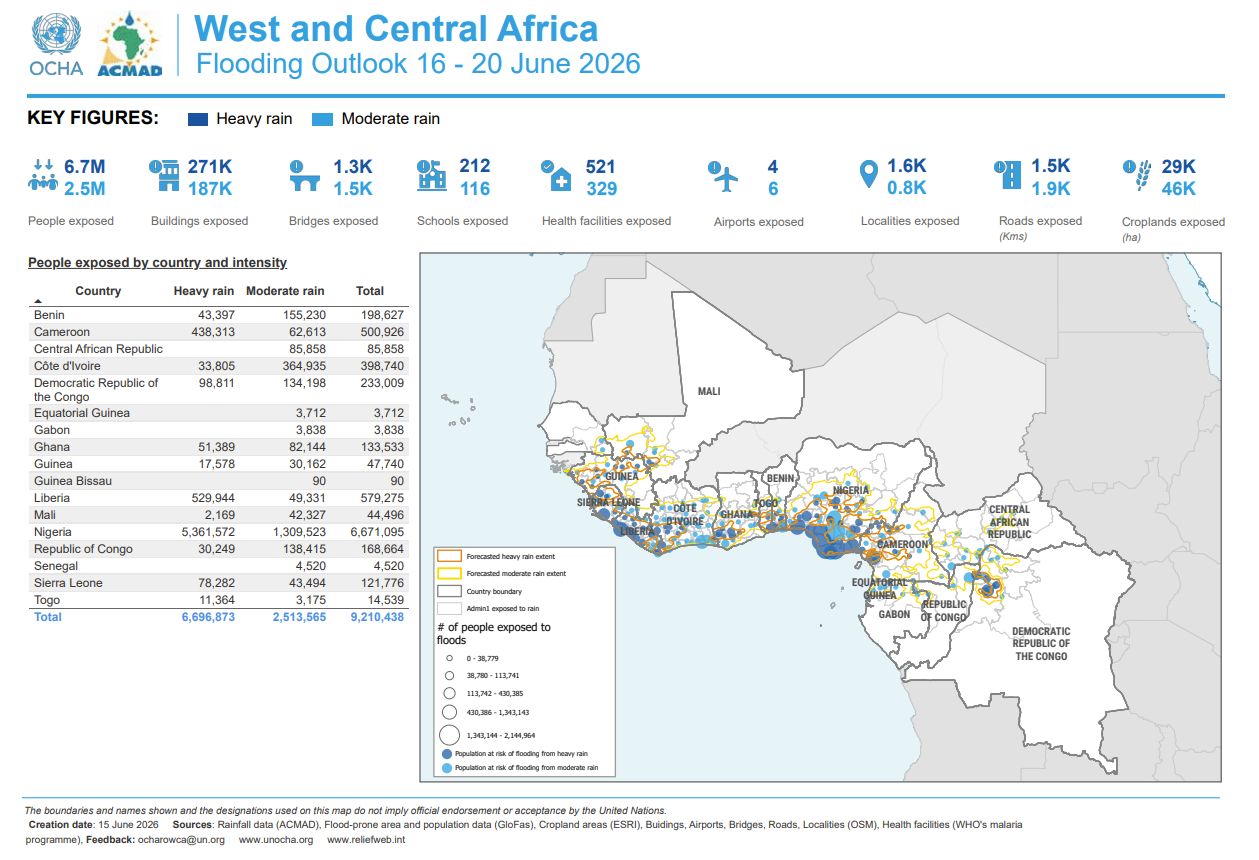
West and Central Africa: Flooding Outlook (16–20 June 2026)
Forecasts for 16–20 June 2026 indicate a high risk of flooding across several countries in West and Central Africa due to widespread moderate and heavy rainfall. Approximately 9.2 million people could be exposed to flooding, including 6.7 million in areas expected to experience heavy rainfall. Nigeria remains the most affected country, with more than 6.6 million people at risk, followed by Liberia, Cameroon, Côte d’Ivoire, and the Democratic Republic of the Congo. Flood exposure could also affect about 271,000 buildings, 1,500 schools, 521 health facilities, 1,300 bridges, 75,000 km of roads, and 75,000 hectares of cropland. The outlook highlights the need for strengthened early warning systems, preparedness measures, and coordinated response efforts to mitigate the potential humanitarian impacts of flooding across the region.
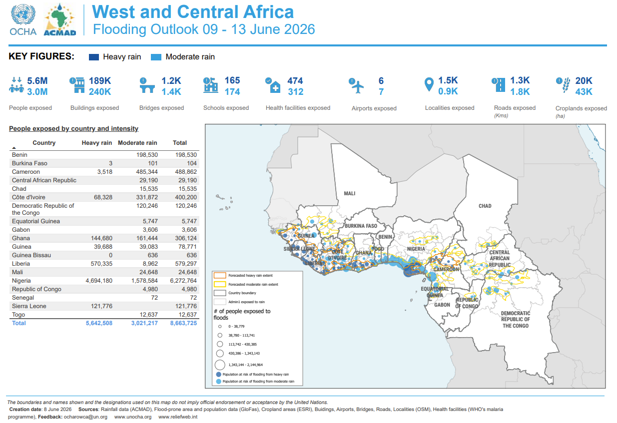
West and Central Africa: 2026 Flooding Outlook (09–13 June 2026)
Forecasts for 9–13 June 2026 indicate a high risk of flooding across several countries in West and Central Africa due to widespread moderate and heavy rainfall. Approximately 8.7 million people could be exposed to flooding, including 5.6 million in areas expected to experience heavy rainfall. Nigeria remains the most affected country, with more than 6.2 million people at risk, followed by Liberia, Cameroon, Côte d’Ivoire, and Ghana. Flood exposure could also affect nearly 430,000 buildings, over 2,600 schools and health facilities combined, 63,000 km of roads, and thousands of hectares of cropland. The outlook underscores the importance of early warning systems, preparedness measures, and coordinated response efforts to reduce the potential humanitarian impact of flooding across the region.
Latest articles
Read the latest editorial content and public updates.

How to prepare a useful submission that is easy to validate
The essential elements to gather before submitting an observation or report in CLIMAP.

From draft to publication: understanding the validation workflow
A simple guide to submission statuses and the role of reviewers.

Data quality is a shared responsibility
Why reliable data depends on both contributors and validation teams.
Frequently asked
Here you'll find detailed answers to the most frequently asked questions about our platform. Whether you want to know more about our features, how to become a reporter or what information is relevant to report, our FAQ is here to guide you and provide you with all the information you need.

- Data collection on the humanitarian impact of floods and other climate events through a submitted form.
- A dashboard for monitoring alerts and disaster forecasts from various sources, including First Alerts by DataMinr, which uses artificial intelligence to scan the web and provide real-time information.
- Integration of Disaster Aware forecasts, which anticipate floods and other climate events.